Jim Fyles and Ian Ritchie are already on the road, heading southwest, towing a trailer full of camping and cooking gear, the field library, and the miscellaneous equipment of field science. This is a post from the road by Jim Fyles.
5:47 am.
The trip has started.
The tires make a quiet crunching sound in the gravel at the end of the dark driveway. By the time we are ready to meet the class in Phoenix, those tires will have turned over 1.5 million rotations. We hope that they are up for it.
A perky voice with an English accent pipes up from the dashboard “Keep left on I271 Expressway Lane, continue 3.4 miles then turn right onto I271 South.” Our route finding is in good hands.
The sky In the rear-view mirror comes alive in pink and gold as we thread Cornwall in a sea of trucks. Geese and ducks (rhymes with trucks), hoping for a tasty invertebrate breakfast, squeeze into ponds in fields waiting for planting. In highway-side wetland forests, the nakedness of the not-quite-spring-yet trees reveals an astonishing number of heron nests; a few herons consider the real estate in the early morning light. A lone porcupine nibbles on the buds atop a tall poplar.
An underlying tension permeates the pastoral scene. And then…it is gone.
The recommended and well-practiced “We are from McGill University and are leading a class field trip to the desert.” has opened the border to us, with not even a “Please open the trailer” let alone a “What is the purpose of that electronic balance?”. Although the tension was unnoticed before, we feel its departure and relax. We are really on our way.
The perky dashboard voice tells us to ‘continue 91 miles to Columbus Ohio.’
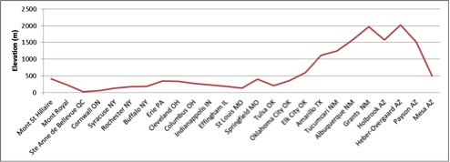
Although locally rolling, even hilly in places, most of North America, apart from some bits out west, is incredibly flat. If we started today’s drive at the top of Mont St. Hilaire (440m elevation) we would not return to that elevation until we reached Missouri or perhaps even Oklahoma (see the chart). Apart from the curvature of the earth, we might indeed be able to see Oklahoma from here.
Oklahoma is a surprise. Although flat, it is not ‘flat’; it is a slope, rising more in elevation from east to west than any state or province that has preceded it on our drive. And the road continues to rise, through Texas and into New Mexico and Arizona peaking more than 2000m above Ste Anne de Bellevue before the steep swooshing decline into the Sonoran Desert.
Mlle. Dashboard tells us “In one mile take exit 119B on right to I270 West”
What she doesn’t tell us is that it is 4:57 pm, nor that we have driven 1103 km so far today, nor that Columbus Ohio is awash with rush hour traffic. Nor that we have miles to go before we sleep.


Reblogged this on Notes de recherche – Research notes and commented:
Remembering with emotion this Desert Ecology course. One of the best academic experiences of my life. Imagine, three weeks of camping in the desert with some of the best professors at McGill. The students of the 2015 edition will nourish this blog for the next three weeks.
Reblogged this on Notes de recherche – Research notes and commented:
Je me remémore avec plaisir ce cours d’Écologie désertique. Une des plus belles expériences de ma vie. Imaginez, trois semaines de camping dans le désert, avec certains des meilleurs professeurs de McGill. Les étudiants de la version 2015 alimenteront ce blog tout au long des prochaines trois semaines.